|
Help About Related Share Your Story General Mall
Food Court Retail Entertainment Management Souvenirs Related Links
|
BaldKnobAR
Bald Knob, ArkansasBald Knob's namesake was a huge, somewhat round rock out-cropping which covered nearly an acre of ground. It was surrounded by a flat rock shelf and could be seen from quite a distance. It was a landmark for many years before it was quarried and used in the construction of the Missouri Pacific Railroad. Legend has it that Hernando De Soto, during his explorations of the Mississippi River Valley in 1541, discovered and named this large rock mound "Bald Knob." It was used by Indians before the coming of the white man as a camping ground during their hunting trips up and down the White River Valley. Later it was used by marauding outlaw bands and slave traders. Cattlemen used the area to assemble their herds for salting, branding and selling after the stately rock was quarried. Today, the quarry remains very much as it was 125 years ago. Several businesses are located around its perimeter. The original top shelf rock remains in only one area which is between V.M.& J. Fur and Jiffy Jerry's. A marker has never been established at this historic site to this day. 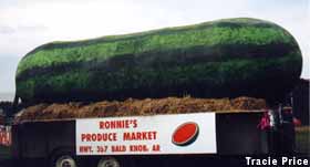 The watermelon is 25-ft. long, lacquered over a steel frame, created for the town's annual parade. Bald Knob was incorporated in 1881. Railroad construction began in 1872. Prior to that there was nothing to mark the present site except for two or three log huts built for temporary use by cattle raisers from the west who brought their herds to graze the rolling foothills and rich White River Delta Plains. Bald Knob and the surrounding area soon became known as "The Strawberry Center of the World." Truck and train car loads of this highly sought after commodity were shipped from the Waller Family Strawberry Market for several years. Other states found they could grow them earlier, but none could grow them any sweeter. Vision and the FutureNow, I love Arkansas, don't get me wrong. It's a beautiful state and is rich in culture and diversity. But 125 years ago, even before town was incorporated, don't you think someone should have told the railroad to go get their rock somewhere other than the local landmark (and future towns namesake)? It's hard to believe that no one thought it was a bad idea. The delta may be short on rocks, but overall Arkansas has lots of rock. There should be a city park around the former 'Bald Knob' rock. This lack of vision 125 years ago haunts Balk Knob today and forever. Memphis leaders should take note to ensure their legacy is not just a big hole in the ground 125 years from now. But you need vision for that......Vision like not razing one of the most historic auditoriums in Memphis to expand the Convention Center. The new facilities may well have been needed, but why put it in a place where than 50 years of Memphis music history had been made. Vision is including the old with the new to make a step forward without losing the past. Something Memphis has yet to do.... Ellis Auditorium Related StoryIn search of the 'knob': Elusive namesake a part of Bald Knob historyBy Tim Bousquet The Daily Citizen Sunday, November 14, 2004 12:43 AM CST 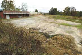 A sandstone terrace hemmed in by vacant tradinc posts and a railroad track is all that remains of the namesake of the city of Bald Knob. The rock hill was mined by rail companies for use as ballast. (Philip Holsinger/The Daily Citizen) Where's Bald Knob? Not the city - the "knob." The assumption is that a place called Bald Knob is named after an actual bald knob, but none is readily evident. The U.S. Geological Survey lists the town at 231 feet elevation, exactly. Its topographic map is slightly more nuanced, showing a contour line of about 220 feet elevation along the railroad tracks, rising gently to about 300 feet at the ridge top behind the school. But nothing on the map stands out as particularly knobish. The locals aren't much help either. "I don't know anything about that," said Gracie Osborne, a clerk at Jiffy Jerry's convenience store on Hwy. 367. "Some of the old folks talk about it, but I haven't really paid attention." Of course, there's always the Internet, and in fact a couple of hundred web sites all have the same story about the naming of Bald Knob. It's not clear who actually wrote the account - the web sites seem to have plagiarized each other, omitting the author's name - but since the story is posted on the semiofficial Chamber of Commerce web site, it has the stamp of authority. "Bald Knob's namesake was a huge, somewhat round rock out-cropping which covered nearly an acre of ground," reads the Chamber's short history of the town. "It was surrounded by a flat rock shelf and could be seen from quite a distance. It was a landmark for many years before it was quarried and used in the construction of the Missouri Pacific Railroad." That much is believable, and goes a long way to explaining why we can't find the knob today. But the rest of the story is questionable, to say the least: "Legend has it that Hernando De Soto, during his explorations of the Mississippi River Valley in 1541, discovered and named this large rock mound 'Bald Knob.' It was used by Indians before the coming of the white man as a camping ground during their hunting trips up and down the White River Valley. Later it was used by marauding outlaw bands and slave traders. Cattlemen used the area to assemble their herds for salting, branding and selling after the stately rock was quarried." De Soto roamed about much of the southeast in an unsuccessful search for gold, but nobody really knows precisely what route he took, a fact which has evidently inspired hundreds of small town boosters to lay dubious claim to the explorer. Having De Soto travel through your burg is the Arkansan equivalent of an east coast town hanging a "George Washington slept here" sign. And no serious historian believes that De Soto was anywhere near Bald Knob. The generally accepted theory is that the closest he came to the place was when he crossed the Mississippi River somewhere around modern-day Memphis. He perhaps made it as far as Parkin before turning south. On the other hand, the whimsical revisionist Donald E. Sheppard suggests that De Soto traveled down the east bank of the White River, in the Augusta area. If so, it's not much of a stretch to believe that De Soto's scouts would have visited Bald Knob. But Sheppard's account is widely contested, and even if it is true, nowhere is there mention of a "bald knob" in any of the De Soto expedition's journals. Moreover, De Soto almost always used Indian place names, and did not newly name places. It was more in the French temperament to use such unromantic descriptive names as "Bald Knob." It was French explorer Bernard de La Harpe, after all, who looked at a granite outcrop on the Arkansas River and named it "La Petite Roche," Little Rock. Certainly lots of French were in the Bald Knob area. Baron de Carondelet, the governor of the Louisiana territory in the late 18th century, granted Don Joseph Vallier rights to property stretching three miles on either side of the White River, including the Bald Knob area. Other French settlers or merchants in the area included Jean Fyatt, Francis Francure, Pierre LaClede and Auguste Choteau. Any of the Frenchmen conceivably could have looked at the rock and called it "La poignée chauve," but attributing the naming rights to some exotic European explorer shortchanges the original native inhabitants and the first Anglo settlers - it doesn't take a college degree to look at a rock and call it "Bald Knob." Indeed, the entire Chamber of Commerce history of Bald Knob seems almost desperately eager to romanticize the place, bringing in Spanish explorers, Indian hunters, marauding outlaw bands and slave traders, as if the day-to-day life of cattle ranchers, downtown merchants and trailer park denizens doesn't have enough drama to sustain interest in and of itself. Regardless, who cares who named the thing - where was it and what happened to it? Of much greater help in all matters Bald Knob is Lincoln Johnson and Elizabeth Short's history, "In and Around the Big Rock." Trouble is, the book is out of print, and it is in great demand. The Searcy Public Library keeps hunting down copies of the book, but as soon as they come in they get stolen, so of late the library keeps only a photocopied version. "The big mass of layered sandstone that stuck up out of the ground," wrote Johnson and Short, "was described by some people as being beautiful; some said it was fairly flat on top, and that it was about an acre big, and it was round. We have described it as resembling a giant wash tub that had been turned upside-down and partially buried, partially sticking up out of the ground." The authors placed the knob on the south side of Hwy. 367, between Jiffy Jerry's and Pearrow's fur store. There is a photo of the knob in the appendix to the book, but as all we have is a photocopy of a photocopy, it is not reproducible here. The photo shows five lonely and scraggly trees atop the knob, and assuming the trees are 25 feet high, the knob itself is about 50 feet high. Frankly, it ain't much. The powers-that-be of the day apparently didn't think much of it either. "The coming of the railroad in 1873 had ended the isolation of the community," wrote Johnson and short. "As railroad company officials passed the big rock, they began to eye it as a source for ballasting material." The authors matter-of factly described the impotence of Bald Knob's nascent environmental movement - "We are told there was a movement from people in the community to keep the rock intact, to not allow it to be broken up. Of course, the movement failed." - but went on to say that quarry operation didn't get started in earnest until 1877. "The first quarry workers had to live in tents, and Arnold Gay tells that there was a 'tent city' near the quarry," they wrote. "The railroad also sent in boxcars that were used for sleeping quarters. Accounts of the number of workers ranged from 50 to 300." Still, for all the industry of the workers, it took another 20 years to chop the knob into non-existence. The 1900 census lists two people employed at the quarry: Bartholomew Holdford was the foreman, overseeing the sole laborer, John Hoben. "We cannot help but look at the site of the old quarry," wrote Johnson and Short, "with a twinge of sadness - to think that the cold, heartless rock that gave so much to the town is all gone - used up by progress, and only a big hole is left of it." Today, it's difficult to even find the remnants of the knob. Hwy. 367 takes an odd swerve between Jiffy Jerry's and the fur store, which only makes sense if you think of a giant rock sticking up in between. A couple of sandstone boulders sit at the rear end of the car wash, and some rubble is strewn about a field behind. More noticeable is the burned out shell of a railroad shop building on the back side of the field and the fur building, which has proven remarkably persistent in its battle against gravity. But just to the east of the fur building is a basketball court-sized slab of sandstone, making a terraced step down to the tracks below. You have to diligently hunt for it to find it, but once you have you've discovered the true Bald Knob. |